
Marine meteorology is the science of monitoring and predicting weather conditions at sea.
For seafarers, it’s not just theory, it’s a critical tool for safety and operational efficiency.
Understanding weather systems helps watchkeepers avoid storms, optimize fuel routes, protect cargo, and comply with STCW bridge watchkeeping duties.
This guide covers the core elements and tools every deck officer must know.
🌐 What Is Marine Meteorology?
Marine meteorology is a specialized field that studies the interaction between the ocean and the atmosphere.
It focuses on oceanic weather systems that directly affect ships, such as:
- 🌬️ Wind and wave behavior
- 🌡️ Temperature and humidity changes
- 🌧️ Precipitation trends over open sea
- ⛈️ Cyclones and pressure systems
- 🌊 Ocean-atmosphere dynamics
- 🛰️ Forecasting tools for route planning
Unlike general meteorology, which includes land-based climates, marine meteorology zooms in on coastal and deep-sea environments where ship crews operate daily under dynamic conditions.

⚓ Why Marine Meteorology Matters for Seafarers
Every decision on the bridge- from adjusting course to delaying cargo operations, can be influenced by weather.
Marine meteorology helps seafarers to:
- ⚠️ Detect and avoid storms or cyclones early
- 💨 Predict rough seas, swells, and poor visibility
- 🧭 Choose optimal and fuel-efficient routes
- 👨✈️ Fulfill watchkeeping duties under STCW
- 📦 Protect sensitive cargo in humid regions
Even seafaring folklore- like “Red sky at night, sailor’s delight”, reflects a long history of weather-watching.
But modern officers rely on instruments and synoptic data for real-time decision-making.

🌦️ 6 Key Elements of Weather at Sea
Watchkeepers observe six essential weather parameters to ensure safety and efficiency at sea.
These elements form the foundation of marine weather logs and forecasts.
🌬️ 1. Wind
- Definition: Horizontal air movement due to pressure differences.
- Impact: Sudden gusts may precede squalls or storms. Strong winds affect maneuvering, anchoring, and fuel consumption.
- Instruments: Anemometer (measures speed), wind vane (shows direction).
- Example: While off the Pakistani coast, we encountered a sudden 60-knot storm-force wind, unreported on NAVTEX, highlighting the value of local wind monitoring.
🌡️ 2. Temperature
- Definition: The thermal energy of the air surrounding the vessel.
- Role: Affects humidity, cloud formation, visibility, and precipitation.
- Instruments: Mercury or digital thermometer mounted outside the bridge.
- Seafarer Tip: A sharp temperature drop often signals rain, fog, or approaching squalls.
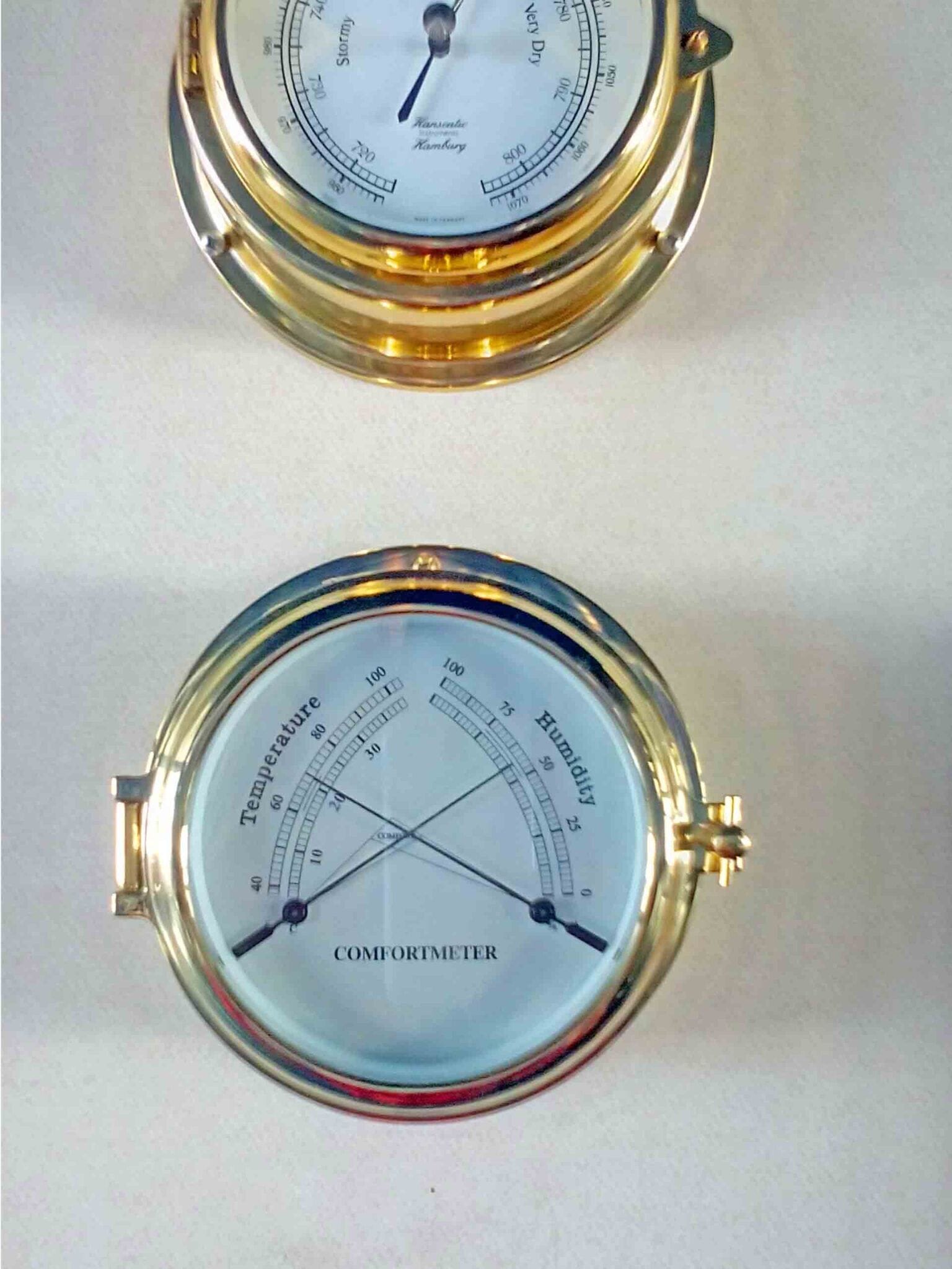
📉 3. Atmospheric Pressure
- Bridge Tip: Monitor pressure trends, not isolated readings. A rapid drop could signal a developing storm system.
- Definition: The force exerted by the weight of air on Earth’s surface.
- Significance: Falling pressure indicates worsening weather; rising pressure suggests clearer skies.
- Normal Range: 970 to 1050 millibars (mb).
- Instrument: Aneroid barometer.
💧 4. Humidity
- Definition: The concentration of water vapor in the air.
- Effect: Influences visibility, cargo conditions, crew comfort, and onboard ventilation.
- Instruments: Hygrometer, comfortmeter, wet and dry bulb thermometers.
- Example: In humid regions like the Middle East, monitoring dew point is crucial to avoid cargo sweating especially for grain, steel, or hygroscopic goods.
🌧️ 5. Precipitation
- Definition: Water falling from the atmosphere in various forms- rain, drizzle, snow, hail, or sleet.
- Operational Impact:
- Reduces radar range and lookout effectiveness
- Delays cargo work and gangway ops
- Affects deck safety due to slippery surfaces
- Tools: Weather fax reports, NAVTEX warnings, and direct visual observation.
- Pro Tip: In heavy rain, reduce reliance on radar and increase bridge lookout intervals.
☁️ 6. Cloudiness
- Definition: The amount and type of cloud coverage observed in the sky.
- Forecasting Clues:
- ☁️ Fast-moving low clouds = frontal system approaching
- 🌩️ Towering cumulonimbus = thunderstorm, squalls, or lightning
- 🌃 Clear night sky = stable conditions next day
- Practical Use: OOWs should know basic cloud types (stratus, cumulus, cirrus, cumulonimbus) for real-time forecasting when digital systems are unavailable.
🧰 Essential Weather Instruments Onboard
To effectively monitor marine weather, every vessel should have these tools available on the bridge:
| Instrument | Purpose |
|---|---|
| Barometer | Measures atmospheric pressure |
| Anemometer | Detects wind speed |
| Wind Vane | Shows wind direction |
| Thermometer | Measures outside air temperature |
| Hygrometer | Records relative humidity |
| Weather Fax | Receives synoptic charts |
| NAVTEX | Provides weather forecasts + warnings |
| Visual Log | Records sky conditions and observations |
🔧 Tip for OOWs: Combine instrument data with personal observation during watchkeeping. Human judgment remains essential especially when automated systems fail.
🚢 Real-World Impact of Marine Weather on Ship Operations
Here’s how marine meteorology affects different onboard departments:
| Shipboard Area | Affected By | Required Action |
|---|---|---|
| Navigation | Wind, waves, poor visibility | Alter course/speed, adjust ETA |
| Deck Operations | Rain, wind, extreme temps | Delay tasks, secure deck gear |
| Cargo Handling | Humidity, rain | Use dehumidifiers, monitor dew point |
| Crew Welfare | Hot/cold climates, humidity | Ensure PPE, hydration, and rest breaks |
❓FAQ: Marine Meteorology for Seafarers
🔹 What’s the difference between weather and climate?
- Weather: Short-term atmospheric changes (hourly to daily).
- Climate: Long-term patterns over decades (30+ years).
🔹 How do seafarers forecast weather onboard?
Seafarers rely on a combination of:
- Meteorological instruments (barometers, thermometers, etc.)
- NAVTEX, weather fax, and satellite charts
- Synoptic map interpretation
- Personal observation of sky and sea behavior
🔹 Which weather element is most important?
All six elements matter, but wind and pressure changes often give the earliest signs of approaching disturbances.
🌤️ Conclusion: Learn to Read the Sky
Mastering marine meteorology gives seafarers an operational edge enabling them to make proactive decisions, minimize risks, and uphold safety.
Even with high-tech equipment onboard, understanding the language of the sky-wind, clouds, pressure, and temperature remains timeless.
“There is nothing new under the sun… but there’s always something coming from it.”
🧭 Stay ahead- observe, log, and act.
May the winds be in your favor.
Leave a Reply