The Long-Range Identification and Tracking (LRIT) system is a global ship monitoring technology mandated by the International Maritime Organization (IMO).
It enables Contracting Governments to track a ship’s identity and position via satellite, even beyond the horizon.
Unlike AIS (Automatic Identification System), which is ship-to-ship and local, LRIT is satellite-based and one-way: ships transmit data but do not receive LRIT info from others.
This system is not designed for onboard use but rather for use by flag States, Port States, and SAR authorities for security, monitoring, and compliance.
📌 Key Point: LRIT is not a navigational aid for the crew- it’s a regulatory tool used by shore-based authorities for global vessel tracking.
🚨 LRIT at a Glance
| Feature | Details |
| Purpose | Long-range vessel monitoring and identification |
| Users | Flag States, Coastal States, Port States, SAR services |
| Data Transmitted | Ship ID, position (latitude/longitude), timestamp |
| Transmission Method | Satellite (and terrestrial backup) |
| Reception | Ships do not receive LRIT data from others |
| Regulation | SOLAS Chapter V, Regulation 19-1 |
| Coverage Area | Sea areas A2, A3, A4 |
🔍 Why Is LRIT Important?
While navigational systems like GPS, radar, and AIS support onboard safety, LRIT focuses on shore-based surveillance and regulatory compliance.
Here are some key uses:
✅ Uses of the LRIT System:
- 📦 Cargo Risk and Threat Management
- 🔐 Maritime Security Monitoring
- 🛟 Search and Rescue Coordination
- 📍 Fleet Tracking by Authorities
- 🌊 Environmental Protection Oversight
- ⚓ Compliance with Port State Controls
⚖️ LRIT Regulatory Framework (SOLAS V/19-1)
The LRIT system is a requirement under:
- SOLAS Chapter V, Regulation 19-1 (introduced via IMO Resolution MSC.202(81))
- Supporting IMO circulars and amendments that govern system architecture and reporting standards
The regulation mandates LRIT installation on specific ship types engaged in international voyages.
🛳️ Ship Types Required to Carry LRIT
Vessels must be LRIT-compliant if they:
- Are constructed on or after 31 December 2008
- Were built before that date but operate in sea areas A2, A3, or A4
- Are engaged in international voyages
✅ Mandatory for:
- 🚢 Passenger ships (including high-speed craft)
- 📦 Cargo ships ≥ 300 GT (including high-speed cargo craft)
- 🛢️ Mobile offshore drilling units (MODUs)
❌ LRIT Exemptions
Ships are exempt from LRIT if they meet both of these criteria:
- Fitted with AIS, regardless of build date
- Operate exclusively in sea area A1
⚠️ Sea Area A1 is typically within VHF coverage (~20–30 nautical miles from shore). LRIT is unnecessary here due to reliable AIS communication.
⚙️ How LRIT Works: Behind the System
The Long-Range Identification and Tracking (LRIT) system is designed for automatic, hands-free operation.
Once activated, it transmits data from the ship to shore without manual input from officers or crew.
Here’s a simplified view of how LRIT transmits vessel data:
- Shipborne LRIT equipment gathers GPS-based location and ship details.
- This data is relayed via a Communication Service Provider (CSP).
- An Application Service Provider (ASP) processes, validates, and forwards the data to a Data Centre.
- The LRIT Data Centre stores, reformats, and routes the data.
- Through the International LRIT Data Exchange (IDE), the data is shared with authorized governments and SAR authorities.
📡 This multi-tiered system ensures global coverage, security, and standardization of ship tracking data.
🧩 Components of the LRIT System
The LRIT architecture consists of six interconnected components, each fulfilling a specific function to enable real-time vessel tracking:
1. 🚢 Shipborne LRIT Equipment
This is the hardware onboard the ship responsible for automatically transmitting the vessel’s:
- Ship ID (e.g., IMO number or MMSI)
- Position (latitude & longitude via GNSS/WGS84)
- Timestamp (in UTC)
It may be:
- A dedicated LRIT terminal, or
- An integrated unit within the GMDSS system
🧭 LRIT terminals require no user input but must remain powered and logged in at all times.
2. 🌐 Communication Service Provider (CSP)
CSPs facilitate secure and reliable transmission of LRIT data between the ship and shore-based facilities.
They handle:
- Data transfer from ship to Data Centre
- Encrypted links between components
- Signal integrity and coverage via satellite or terrestrial networks
Popular CSPs include Inmarsat and Iridium-based networks, depending on region and vessel coverage.
3. 📡 Application Service Provider (ASP)
ASPs manage how LRIT data is structured, scheduled, and routed. Key roles include:
- Managing data frequency (default: every 6 hours)
- Pausing/resuming transmissions upon request
- Routing data to the correct LRIT Data Centre
- Enriching data with:
- Ship type and name
- ASP receive and forward timestamps
- LRIT Data Centre identifiers
🔐 ASPs ensure transparency, traceability, and system compliance.
4. 🗃️ LRIT Data Centre
Each LRIT Data Centre is the central hub for collecting and redistributing LRIT information. They can be:
- National (e.g., Japan LRIT DC)
- Regional or Cooperative
- The International LRIT DC
Their tasks include:
- Storing historical data
- Responding to authorized requests
- Sharing info with SAR, PSC, and maritime authorities
5. 🧭 Data Distribution Plan (DDP)
The DDP defines how LRIT data is shared between:
- LRIT Data Centres
- Contracting Governments
- Data Users (e.g., search and rescue services)
It sets:
- Who can access which data
- Geographic zones
- Data retention timelines
- Security and access control protocols
6. 🌍 International LRIT Data Exchange (IDE)
The IDE ensures that LRIT data flows seamlessly across borders, enabling:
- Global interoperability
- Standardized data formats
- Authorized sharing between countries
The IDE is managed under the IMO’s oversight and connects all Data Centres and Coordinators worldwide.
🌐 Without the IDE, international coordination in maritime security, SAR, and flag State control would be fragmented.

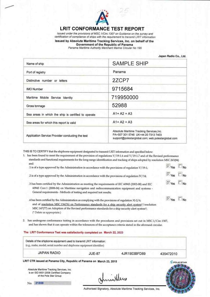
🧪 LRIT Conformance Test Report (CTR)
Before a vessel can officially operate its LRIT system, it must pass a Conformance Test conducted by an authorized Application Service Provider (ASP).
The purpose of this test is to verify that the ship’s equipment:
- Meets IMO performance standards
- Functions correctly and reliably
- Transmits accurate and complete data per regulation
✅ Upon passing, the vessel receives a Conformance Test Report (CTR), which must be kept onboard as proof of compliance.
📋 LRIT Conformance Test Checklist
During the CTR process, the following aspects are verified:
| ✅ Test Criteria |
| Equipment is activated within the ASP network |
| Proper sea area (A2, A3, A4) identification |
| Automatic transmission of LRIT data |
| Presence of ship identity in the transmission |
| GNSS-based positional data (WGS84 Datum) |
| Timestamp present in UTC format |
| Position report includes ship’s exact coordinates |
| Transmission occurs at default 6-hour intervals |
| Successfully reconfigured to transmit at 15, 24, 60 minutes |
| Polling requests are received and responded to |
| Data becomes available within 15–30 minutes of sending |
| Equipment is type-approved by the flag Administration |
| Complies with IMO Res. A.694(17) (EMC compliance) |
| Connected to both main and emergency power supplies |
📂 The completed Conformance Test Report should be retained onboard and presented during flag State or port State inspections.
🚨 LRIT vs. Other Shipboard Systems
While many bridge systems (radar, AIS, ECDIS) are designed for onboard situational awareness, the LRIT system serves external monitoring functions:
| System | Main Function | User |
| LRIT | Global ship tracking | Governments/SAR |
| AIS | Local ship tracking | Nearby vessels |
| SSAS | Security alert | Flag State |
| GMDSS | Emergency comms | RCCs, ships |
🛡️ LRIT contributes to maritime domain awareness (MDA), international security, and compliance- not navigation.
🧭 Final Thoughts: Why LRIT Matters for Seafarers
Even if bridge teams don’t interact with LRIT daily, understanding its purpose and compliance requirements is vital. It ensures:
- Smooth flag and port State inspections
- Global tracking readiness during emergencies
- Compliance with SOLAS and IMO mandates
As a seafarer, ensure your LRIT terminal is powered, logged in, and tested. Familiarity with the CTR process can also help during audits or PSC checks.
📌 Frequently Asked Questions (FAQs)
🔸 What does LRIT stand for?
LRIT stands for Long-Range Identification and Tracking, a system for globally tracking ship positions and identities via satellite.
🔸 Is LRIT mandatory for all ships?
No. Only SOLAS-compliant ships of certain types (e.g., passenger, cargo ≥300 GT, MODUs) engaged in international voyages must carry LRIT, unless exempted.
🔸 Who can access LRIT data?
Only authorized flag States, port States, search and rescue services, and contracting governments can access LRIT data.
🔸 What is the default LRIT reporting interval?
The standard reporting frequency is every 6 hours, but it can be changed (e.g., 15, 30, 60 minutes) by request through an authorized provider.
✅ Conclusion
The LRIT system might operate silently in the background, but its role in enhancing maritime safety, global security, and regulatory compliance is undeniable.
As part of your vessel’s safety management system, LRIT must be understood- not just installed.
🧭 Keep it powered. Keep it compliant. Stay aware.
📣 Call to Action:
Got questions about LRIT certification or conformance testing?
Drop them in the comments or reach out via Captain’s Mode Contact Page. ⚓🌐
May the winds be in your favor.
Leave a Reply