The IALA Buoyage System is a standardized global system of Aids to Navigation (AtoN) developed by the International Organization for Marine Aids to Navigation (IALA), formerly the International Association of Marine Aids to Navigation and Lighthouse Authorities.
It ensures vessels navigate safely through channels, avoid hazards, and enter or leave ports correctly.
This system uses buoys, beacons, lights, topmarks, and shapes, each with specific meanings based on location and direction of travel.
It’s the maritime version of road signs for ships.
IALA Regions A and B: Key Difference
IALA divides the world into two buoyage regions:
| Region | Port Side Buoy (Inbound) | Starboard Side Buoy (Inbound) | Used In |
| Region A | Red (Can Shape) | Green (Cone Shape) | Africa, Australia, Europe, India, New Zealand, The Gulfs, and most of Asia. |
| Region B | Green (Can Shape) | Red (Cone Shape) | North, Central, and South America, North and South Korea, Japan, and the Philippines. |
Inbound = entering a harbor or port
Outbound = leaving the port toward open sea
Knowing your current region is crucial before applying buoyage rules. This is normally handled by the Second Mate, but the entire bridge team must verify it.
Quick History of IALA Buoyage
- 1889: Earliest date where countries agreed to mark port channels with black cans and starboard with red cones.
- Problem: U.S. and European systems conflicted on light colors leading to navigational confusion.
- 1936: League of Nations attempted to introduce Lateral and Cardinal Systems, but few countries followed.
- 1957: IALA was formed to unify Aids to Navigation under one global standard.
What Is IALA?
IALA originally stood for the International Association of Marine Aids to Navigation and Lighthouse Authorities, founded in 1957 as a non-governmental organization (NGO).
Its primary mission has always been to promote harmonized Aids to Navigation (AtoN) for safe, efficient, and sustainable maritime operations worldwide.
Name Change (Effective August 22, 2024)
On August 22, 2024, IALA officially became an Intergovernmental Organization (IGO) and changed its name to:
International Organization for Marine Aids to Navigation
This change came into effect following the ratification or accession of the IALA Convention by 30 member States.
Purpose
- Develop and maintain global standards for:
- Buoyage systems
- Light characteristics
- Shapes, colors, and positioning of navigational aids
- Enhance safety of marine navigation, protect the environment, and improve efficiency of vessel movements.
Common Misconception
Many seafarers mistakenly refer to the buoyage system itself as “IALA.”
- Correct usage: “IALA Buoyage System” or “IALA Region A/B”
- Incorrect: “Follow the IALA”
Remember: IALA is the governing organization, not the name of the system.

Overview of IALA Marks (Types of Buoys)
The new IALA Buoyage System includes seven primary types of marks, each with distinct colors, shapes, topmarks, and lights:
- Lateral Marks – Define channel sides
- Cardinal Marks – Show safest water relative to danger
- Isolated Danger Marks – Warn of a hazard with navigable water around
- Safe Water Marks – Indicate open, safe water all around
- Special Marks – Mark areas with specific purposes (e.g., military zones)
- Emergency Wreck Marking Buoy – Mark recently discovered wrecks
- Other Marks – Includes lighthouses, leading lights or ranges, sector lights, beacons, major floating aids, and auxiliary marks.
We’ll cover the first two below.
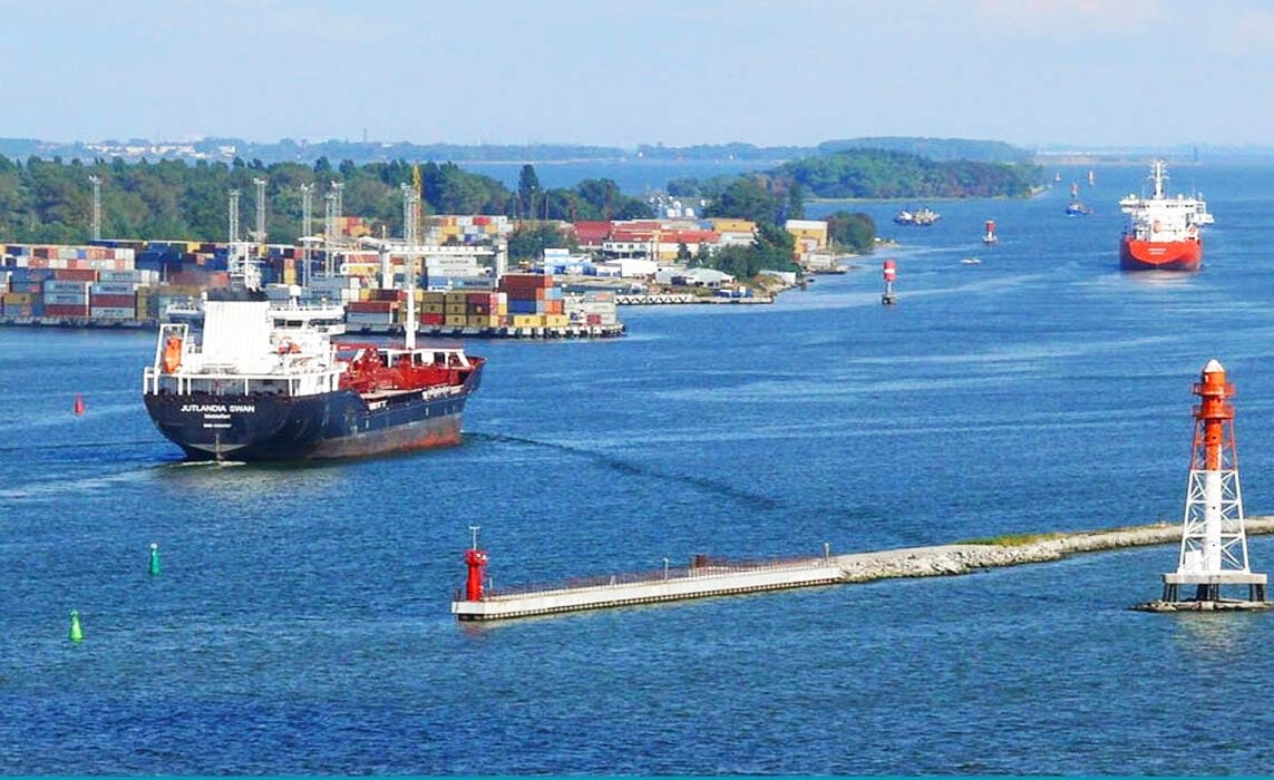
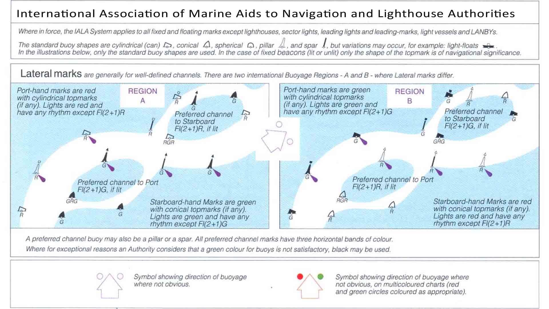
1. Lateral Marks (Channel Navigation Aids)
Lateral marks indicate the port and starboard sides of a navigable channel based on the direction of buoyage (inbound or outbound).
Their appearance depends on the region.
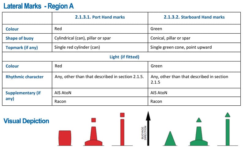
Region A: (Used in Asia, Europe, Australia)
| Direction | Port Side | Starboard Side |
|---|---|---|
| Inbound | Red can-shaped buoys | Green cone-shaped buoys |
| Outbound | Green on port | Red on starboard |
Example countries: Africa, Australia, Europe, India, New Zealand, The Gulfs, and most of Asia.
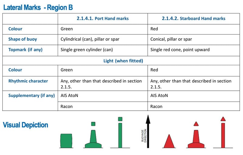
Region B: (Used in Americas, Philippines, Japan)
| Direction | Port Side | Starboard Side |
|---|---|---|
| Inbound | Green can-shaped buoys | Red cone-shaped buoys |
| Outbound | Red on port | Green on starboard |
Example countries: USA, Canada, South America, Japan, Korea, Philippines
TIP: Look out for Preferred Channel Marks when a channel splits – these show the main route vs. secondary passage.
2. Cardinal Marks (Compass-Based Aids)
Cardinal marks indicate where safe water lies in relation to a hazard, using compass directions: North, South, East, and West.
How to Interpret:
| Buoy Name | Safe Side | Light Flashes | Topmark Shape | Buoy Color |
| North Cardinal Mark | Pass North of the mark | Continuous flashes | ▲ ▲ | Black above yellow |
| South Cardinal Mark | Pass South of the mark | 6 short + 1 long | ▼ ▼ | Yellow above black |
| East Cardinal Mark | Pass East of the mark | 3 flashes | ▲ ▼ | Black with a single broad horizontal yellow band |
| West Cardinal Mark | Pass West of the mark | 9 flashes | ▼ ▲ | Yellow with a single broad horizontal black band |
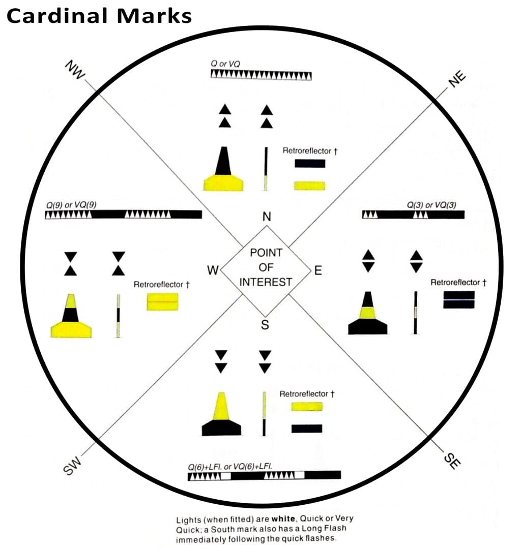
Easy Mnemonics:
- West = Wine Glass (topmark shape) or YelloWWW-Black-YelloWWWest (ends in W)
- North = All Black Top
- Use the light pattern like a clock:
- North = Continuous Quick or Very Quick flashes
- East = 3 group flashes (3 o’clock)
- South = 6 group flashes (6 o’clock)
- West = 9 group flashes (9 o’clock)

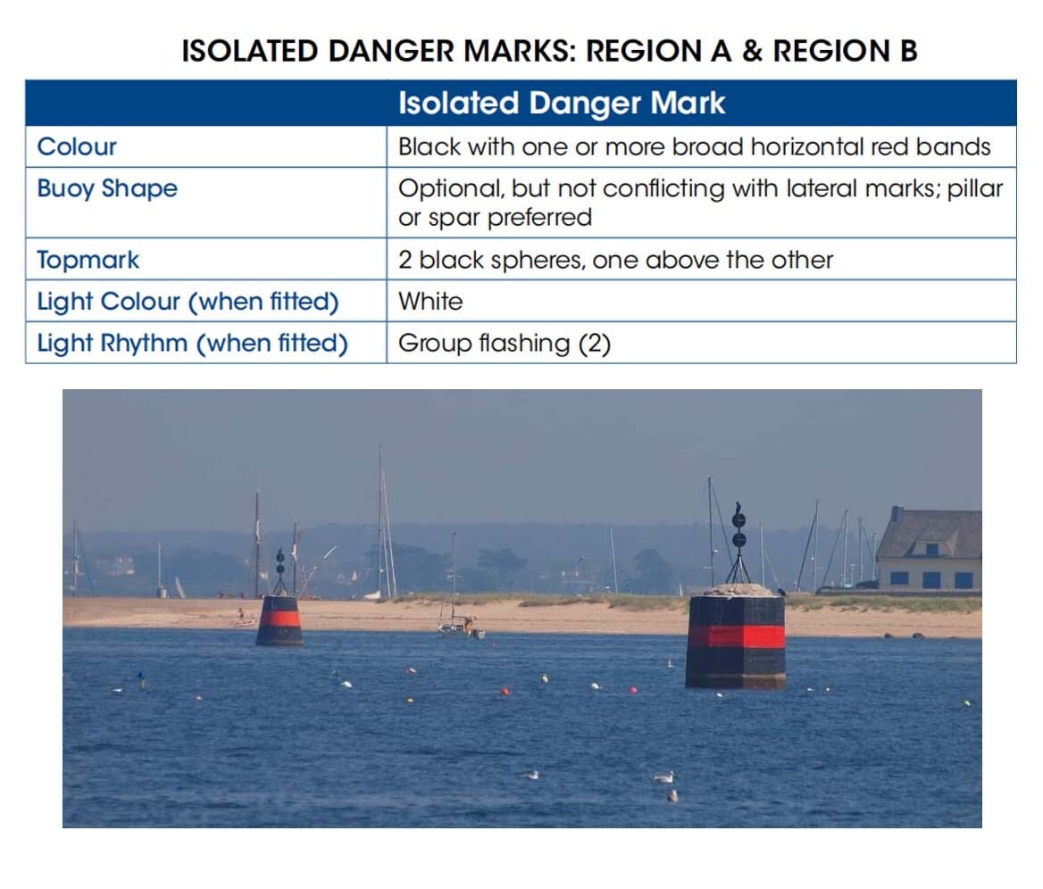
3. Isolated Danger Marks
Purpose: Warn of a specific hazard (e.g., submerged rock or wreck) with safe water all around.
Key Characteristics:
- Color: Black with one red horizontal band
- Topmark: Two black spheres, placed vertically
- Shape: Usually pillar or spar
- Light: Group of two white flashes
When to Use:
You’ll encounter this when passing near shoals, wrecks, or rocks– especially in narrow channels or offshore zones.
Always navigate around the buoy, not close to it.
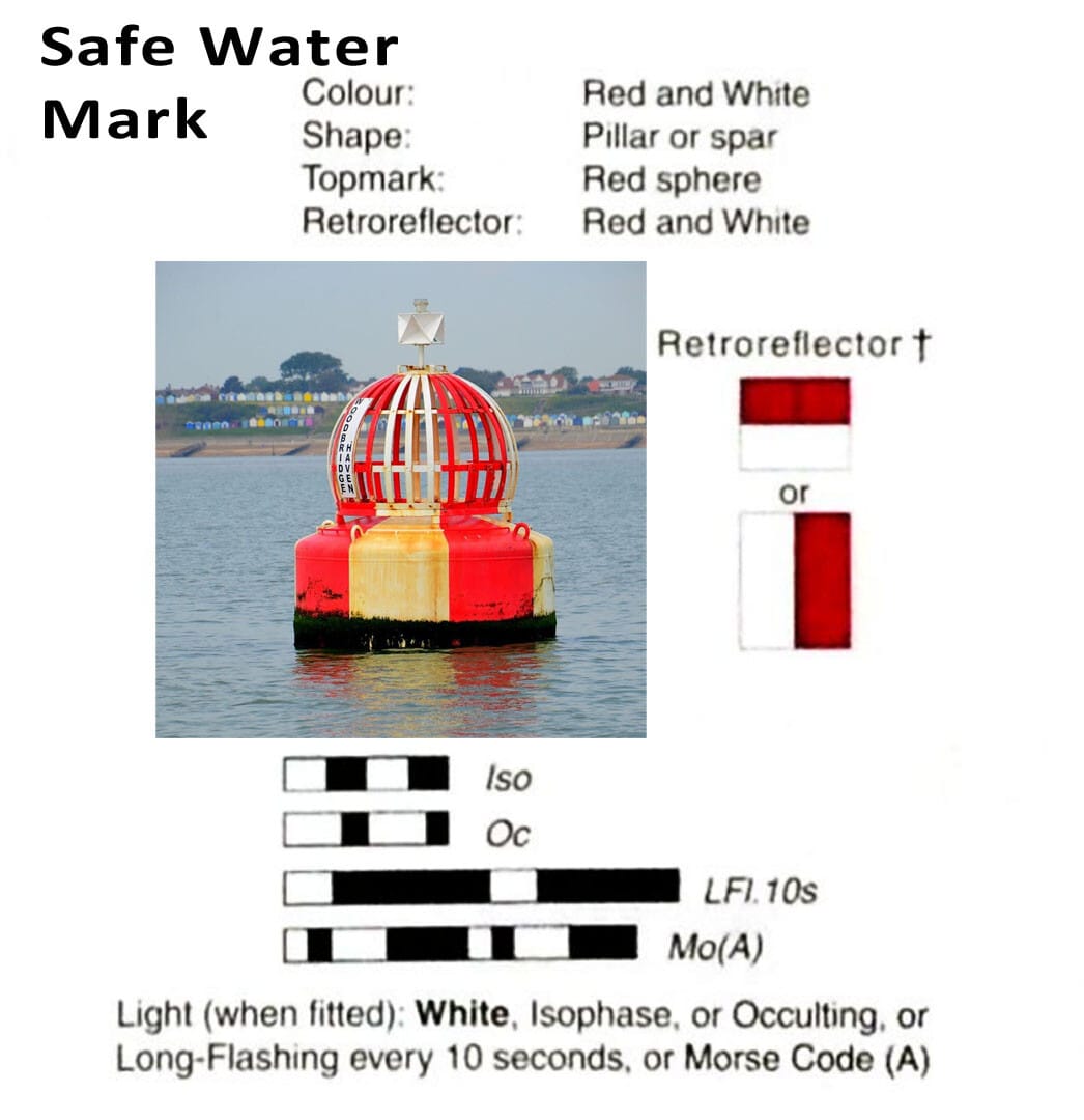
4. Safe Water Marks
Purpose: Indicates navigable water exists in all directions around the mark.
Key Characteristics:
- Color: Red and white vertical stripes
- Topmark: Single red sphere
- Shape: Often a spar or pillar buoy
- Light: Isophase, Occulting, or Long Flash White every 10 seconds
Where You’ll Find It:
- Approaching landfall or harbor entrances
- Mid-channel or centerline indicators
- Used to mark fairways or best passage in bridge crossings
Tip: This is the opposite of an isolated danger mark-it’s an “all-clear” signal.
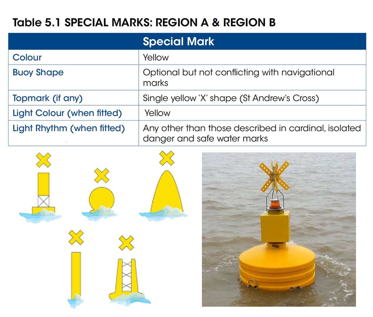
5. Special Marks
Purpose: Mark zones with specific, non-navigation-related purposes. These do not indicate danger but require attention.
Common Uses:
- Military exercise areas
- Recreational zones
- ODAS buoys (Ocean Data Acquisition Systems)
- Traffic separation marks where use of conventional channel marking may cause confusion
- Cable or pipeline areas
- Boundaries of anchorage areas
- Man-made structures
- Aquaculture
- Mooring buoys
- Moving object / hazard (MAtoN)
- Spoil grounds or anchorage limits
Key Characteristics:
- Color: Yellow
- Topmark: Yellow “X” (St. Andrew’s Cross)
- Light: Yellow flashing (distinct from cardinal/lateral marks)
Important:
Always consult nautical charts to understand what a special mark is designating in your area.
They vary widely in purpose.
6. Emergency Wreck Marking Buoys
Purpose: Temporarily mark newly discovered wrecks not yet shown on nautical charts.
Background:
- Introduced after a 2002 maritime incident in the Strait of Dover, where multiple ships struck the same sunken wreck even though it was marked.
- Designed for maximum visibility and clarity.

Key Characteristics:
- Color: Blue and yellow vertical stripes
- Topmark: Upright yellow cross
- Light: Alternating blue and yellow (1-second flash of each)
- Deployed: Within 72 hours of the wreck detection
These buoys are temporary. Once a proper wreck survey is complete and long-term markings are in place, they are removed.
7. Other Marks
The new IALA also defines additional Aids to Navigation (AtoN) essential for coastal, harbor, and offshore safety.
These fixed or floating structures serve specialized functions in guiding vessels and enhancing marine situational awareness.
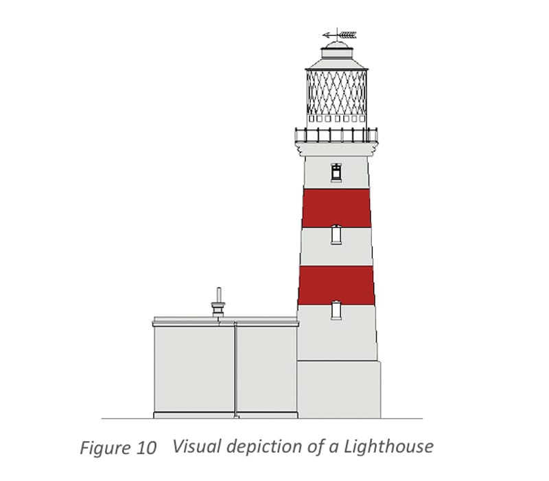
Lighthouses
Definition:
A lighthouse is a tall, often tower-like structure erected at strategic geographic locations to:
- Carry a signal light (long/medium-range)
- Act as a prominent daymark
Description:
Modern lighthouses may incorporate:
- Sector lights (directional arcs)
- AIS AtoN, Racons, DGNSS, VHF/VDES
- Illumination for night identification (per IALA guidance)
Used for long-distance visibility, harbor entries, rocky coasts, and isolated danger zones.
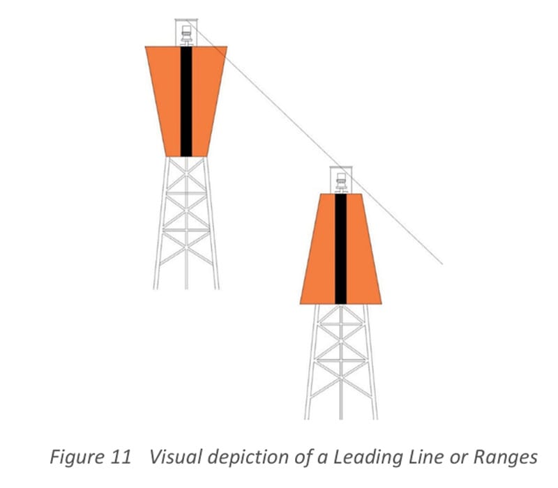
Leading Lines (Ranges)
Definition:
Leading Lines (or Ranges) consist of two or more marks aligned vertically. Mariners steer along the line to maintain safe passage.
Description:
- May be any color or shape, as long as it is distinct from surroundings.
- Can be fixed structures, lights, or a combination.
- Common in river entries, narrow channels, or turning basins.
When both marks align vertically, you are on the correct course.
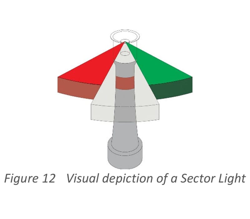
Sector Lights
Definition:
A sector light is a fixed marine light showing different colors or rhythms over designated arcs to indicate direction or hazards.
Description:
Used to:
- Mark safe water sectors in fairways
- Indicate turning points or channel junctions
- Warn of hazards or restricted zones
Sector colors typically mean:
- White: Safe water
- Red or Green: Hazard or limit of safe channel
Beacons
Definition:
A beacon is a fixed navigation mark identifiable by shape, color, topmark, or light character.
General Rules:
- If lighted, it’s called a light beacon
- If unlighted, it serves as a daymark
- Often used as part of leading lines
- Can act as radar targets if fitted with reflectors
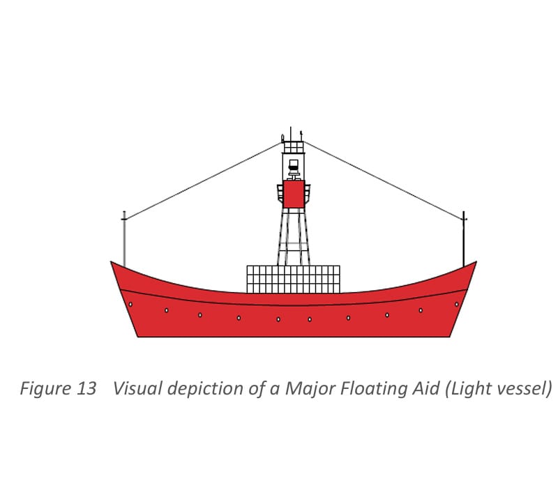
Major Floating Aids
Definition:
Major floating aids include lightvessels, light floats, and large navigational buoys positioned in offshore areas or high-traffic zones.
Description:
They serve as:
- Approach aids from open sea
- Platforms for:
- AIS AtoN
- Racons
- VHF/VDES
- Markers for high-risk or critical locations
Used in areas where fixed structures are impractical due to depth or distance.
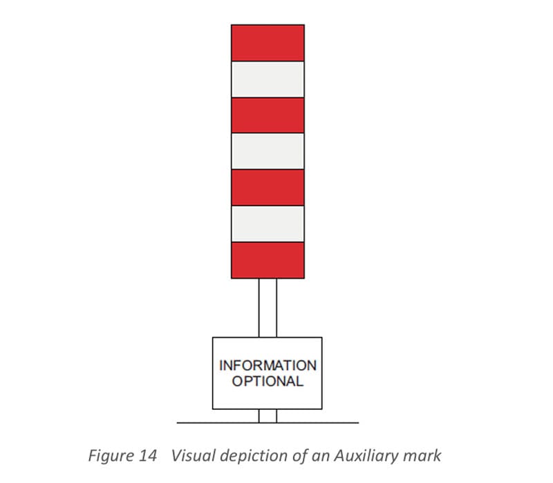
🧩 Auxiliary Marks
Definition:
Auxiliary marks are minor AtoN that fall outside the six main types.
Description:
- Typically placed outside standard channels
- Do not mark port/starboard sides or obstructions
- May convey navigational safety info
- Must be published in nautical charts or sailing directions
- Must not conflict with standard IALA marks
Uniformity Across IALA Regions
Whether in Region A or B, all seven buoy types use the same meaning and appearance (except Lateral Marks).
This standardization by IALA ensures:
- Consistent navigation worldwide
- Simplified seafarer training
- Enhanced safety in global ports and waterways
Final Thoughts: Why Every Seafarer Must Master IALA Buoyage
Understanding the IALA Buoyage System is essential for:
- Bridge watchkeeping duties
- Port approaches and coastal navigation
- Avoiding hazards and accidents
- Passing marine certification and oral exams
Whether you’re a deck cadet, second mate, or preparing for officer exams, mastering these marks will boost your confidence and navigation skills.
FAQs Frequently Asked Questions
What is the difference between Region A and Region B in IALA?
- Region A: Red port, green starboard (Europe, Asia, Africa)
- Region B: Green port, red starboard (Americas, Philippines, Japan)
What color is a cardinal mark?
- Yellow and black in specific patterns, depending on the cardinal direction.
What does a safe water mark indicate?
There is navigable water all around the mark.
May the winds be in your favor
Leave a Reply