
NavTex (Navigational Telex) is an international automated broadcast system that transmits Maritime Safety Information (MSI) such as navigational warnings, weather forecasts, and SAR alerts directly to ships.
It operates as part of the GMDSS (Global Maritime Distress and Safety System) using dedicated medium and high frequencies (518 kHz, 490 kHz, 4209.5 kHz) and reaches up to 400 NM offshore.
Despite the rise of satellite and internet communications, NavTex remains a mandatory and reliable tool for ships worldwide.
🧭 Why NavTex Still Matters in Modern Navigation
Even with satellite internet, ECDIS, and real-time onboard communications, NavTex is irreplaceable due to its:
- 📡 Automatic broadcasts without user request
- 🌊 Global coverage via coastal stations and NAVAREAs
- 📑 Regulatory compliance under SOLAS and GMDSS
- 🔒 Reliability and independence from internet or cloud-based services
💡 Pro tip: Some modern ECDIS systems now integrate paperless NavTex receivers, replacing older print-only units to streamline bridge operations.
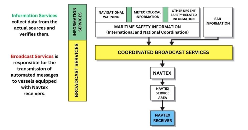
⚙️ How NavTex Works: Two Core Services
NavTex functions through a two-tier system that ensures accurate message generation and global delivery:
1️⃣ Information Services
These services collect, verify, and coordinate maritime safety data from sources such as:
- Hydrographic offices
- Meteorological centers
- Search and Rescue (SAR) coordinators
✅ Each message is filtered by national or international MSI coordinators to prevent duplication and ensure data quality.
2️⃣ Broadcast Services
Broadcast stations then transmit MSI using automated narrow-band direct-printing (NBDP).
Messages are directed to specific NAVAREAs and transmitted in a standardized format via coastal transmitters.
📡 Transmission Range: 200 to 400 nautical miles
🗺️ Targeted Regions: Based on NAVAREA coverage zones
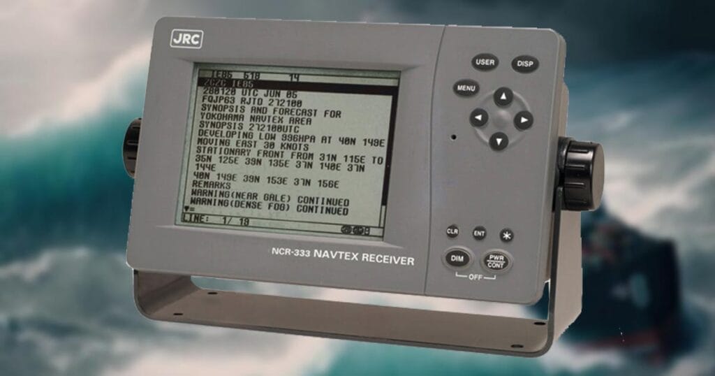
📦 Components of a Ship’s NavTex Receiver
Though compact, NavTex receivers are mission-critical bridge equipment. Here’s a breakdown of their components:
| Component | Function |
| Antenna Unit | Captures signals from NavTex stations and sends them to the receiver |
| Receiver Unit | Tunes to selected frequencies (518/490/4209.5 kHz), demodulates and decodes messages |
| Control Unit | Interface for selecting languages, message types, and station codes |
| Display Unit | Shows decoded messages; IMO requires minimum 16 lines × 32 characters |
| Printer (optional) | Some models auto-print messages; newer units may be paperless |
| Power Supply | Ensures uninterrupted operation of the entire NavTex system |
🛠️ Note: Display and interface requirements follow the IMO NavTex Manual.
📡 NavTex Frequencies Explained (GMDSS Compliance)
NavTex operates on three standard frequencies, all approved under IMO Resolutions A.706(17) and A.1051(27).
📶 518 kHz – International NavTex
- Language: English only
- Coverage: 200–400 NM
- Usage: Sea Areas A1 and A2
- 🗺️ Global standard under GMDSS
📶 490 kHz – National NavTex
- Language: Local languages (plus English, optional)
- Usage: Country-specific coastal coverage
- 🔁 Often runs parallel with 518 kHz to support national MSI
📶 4209.5 kHz – Supplementary National NavTex
- Purpose: Supports overflow or additional regional messages
- Usage: Less common, but active in some countries
- 💡 High-frequency (HF) use allows longer-range coverage under some conditions
⚠️ Important: While 518 kHz is mandatory under SOLAS, usage of 490 kHz and 4209.5 kHz may vary depending on the ship’s flag state and region.
🌐 What are NAVAREAs in NavTex?
NAVAREAs (Navigational Areas) are large maritime zones designated by the International Maritime Organization (IMO) under the Worldwide Navigational Warning Service (WWNWS).
Their main role is to organize and standardize the distribution of Maritime Safety Information (MSI) to ships around the globe.
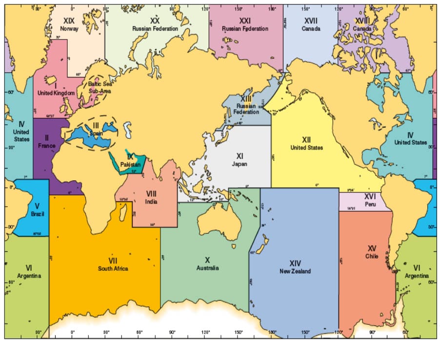
🌍 Key Facts About NAVAREAs
- There are 21 NAVAREAs, numbered I to XXI using Roman numerals.
- Each NAVAREA is managed by a NAVAREA Coordinator responsible for broadcasting relevant MSI.
- Coverage includes multiple countries and vast ocean areas.
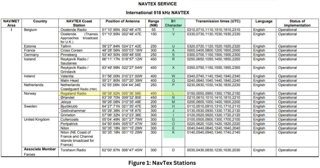
- NavTex stations within each NAVAREA transmit on assigned frequencies (usually 518 kHz and 490 kHz).
📌 Example:
NAVAREA I (covering the North Sea and northeastern Atlantic) includes several UK, French, and Norwegian broadcast stations each using unique identifiers.
🧭 For bridge watchkeepers, it’s crucial to configure your NavTex to receive messages from the correct NAVAREA and station IDs based on your current voyage plan.
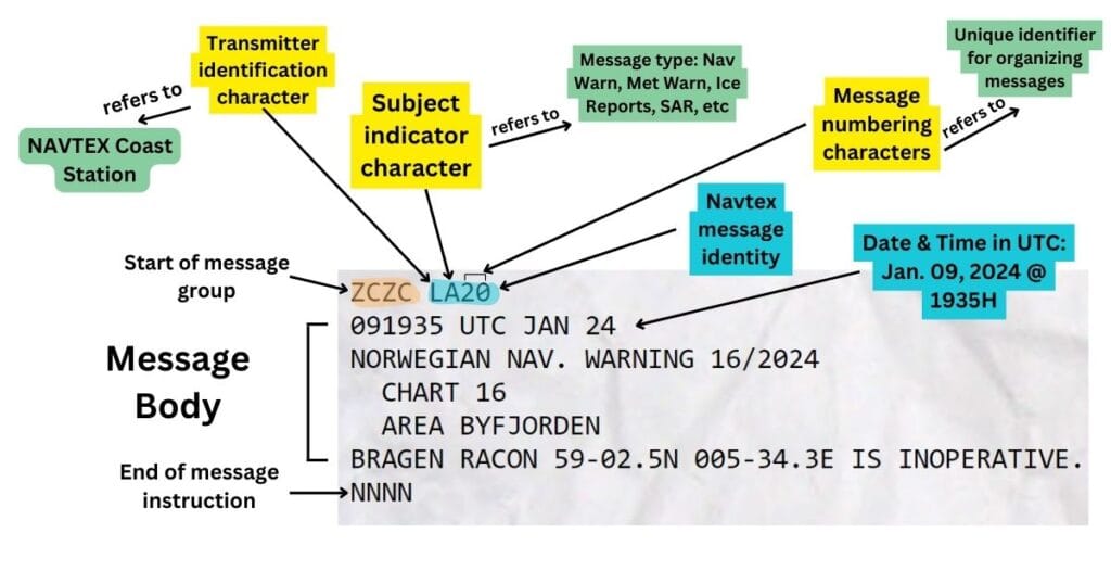
🧾 NavTex Message Format and Decoding
NavTex messages follow a standard coded structure to allow compact and efficient transmission even on screens with limited space.
🧷 Standard NavTex Message Format
ZCZCB1B2B3B4[Message Text]NNNN| Code | Meaning |
| ZCZC | Start of message identifier |
| B1 | Transmitter Identification Character (Station Code) |
| B2 | Subject Indicator Character (Message Type) |
| B3B4 | Message Numbering Characters (Sequential: 01–99) |
| NNNN | End of message identifier |
🗂️ Subject Indicator Codes (B2)
| Code | Description |
| A | Navigational warnings (Mandatory) |
| B | Meteorological warnings (Mandatory) |
| D | Search and Rescue (SAR) information (Mandatory) |
| L | Long-range navigational aids (e.g., LORAN) (Mandatory) |
| … | Other codes cover Ice Reports, Piracy Warnings, Meteorological Forecasts, etc. |
⚠️ Note: Codes A, B, D, and L are mandatory under GMDSS and cannot be deselected on shipboard NavTex receivers.
🧠 Example NavTex Message Breakdown
ZCZC BA12
NAV WARNING: SHOAL REPORTED AT 52N 003E
NNNN- B1 (B): Station “B” transmitting
- B2 (A): Navigational warning
- B3B4 (12): 12th message in sequence
- Message: Shoal warning with coordinates
- ZCZC / NNNN: Marks beginning and end of the transmission
✅ Best Practice: Officers of the Watch (OOWs) should routinely check for new, unduplicated messages, especially when entering a new NAVAREA or switching frequencies.
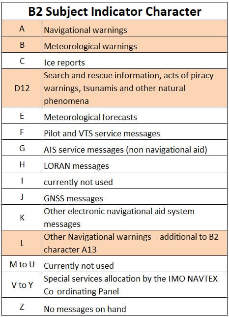
Subject lines A, B, D, and L are in light brown highlight to emphasize that these indicators are mandatory and cannot be deselected on the NAVTEX receiver.
This ensures that ships using this equipment always receive the most vital information.
📚 Final Thoughts
NavTex may seem like an old-school system, but it continues to play a crucial role in maritime safety.
From mandatory message categories to NAVAREA broadcasting zones and coded formats, it delivers mission-critical information automatically, reliably, and globally.
🧭 Whether you’re in coastal waters or deep sea, a properly tuned NavTex receiver ensures your vessel stays updated on navigational hazards, bad weather, or SAR alerts without needing internet or manual downloads.
❓ FAQ: NavTex in Maritime Use
🔹 What is NavTex used for?
NavTex is used to automatically receive Maritime Safety Information (MSI), including navigational warnings, weather forecasts, and distress messages.
🔹 What frequencies does NavTex use?
NavTex transmits on 518 kHz (international), 490 kHz (national), and 4209.5 kHz (HF backup) frequencies.
🔹 Is NavTex still required in 2025 and beyond?
Yes. Under SOLAS and GMDSS regulations, ships are still required to carry operational NavTex receivers.
🔹 Can NavTex messages be received digitally?
Yes. Modern receivers support paperless message display and can integrate into ECDIS and bridge alert systems.
📢 Call to Action
⚓ Ensure your vessel’s NavTex receiver is properly configured, tuned to the right NAVAREA, and regularly checked by bridge personnel.
📘 Want to learn more about GMDSS components like EPIRBs, SARTs, or EGC?
👉Send us a message or comment below so we can send you our GMDSS Infographic guide
May the winds be in your favor.
Leave a Reply