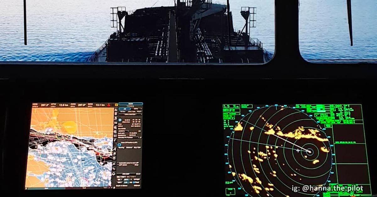
The Electronic Chart Display and Information System (ECDIS) has revolutionized maritime navigation by replacing bulky paper charts with a dynamic, computer-based system.
Endorsed by IMO and mandated by SOLAS, ECDIS is now standard equipment aboard merchant vessels.
Once met with skepticism, ECDIS has become a critical tool for deck officers, offering real-time navigation, improved safety, and compliance with international maritime standards.
Here’s one mariner who discovered the importance of this technology 10 years ago.
I had never sailed on a vessel with ECDIS till March last year (2013). Over a long 20 days of sailing, I familiarised myself well with it. On arriving in Brazil, I was made to shift anchorage ten times in seven days due to local regulations. Believe me, that was the time I realised how useful ECDIS is to a navigator!
G B Singh AFNI – Issue 5: ECDIS – The Future Of Navigation (LR)
🔍 What Is ECDIS?
ECDIS (Electronic Chart Display and Information System) is a digital navigation system that integrates Electronic Navigational Charts (ENCs), sensor inputs (like GPS, AIS, radar), and other navigation tools to provide real-time situational awareness.
🧭 Think of it as the mariner’s version of Google Maps, capable of:
- Showing vessel position and track
- Creating and monitoring routes
- Displaying AIS targets and radar overlays
- Alerting hazards or route deviations
📌 Most importantly, ECDIS meets the IMO performance standards and satisfies the chart carriage requirement under SOLAS Chapter V, Regulation 19.
⚓ Why ECDIS Matters to Modern Seafarers
Many seafarers today wouldn’t go back to traditional paper charts and here’s why:
✅ 1. Enhanced Navigational Safety
ECDIS displays:
- Real-time ship position
- Depth contours and underwater hazards
- Buoyage systems and aids to navigation
- Proximity of nearby vessels (via AIS integration)
These features help prevent collisions and groundings, especially in confined waters.
🎯 2. Precise and Continuous Navigation
By integrating GPS, DGPS, and ENCs, ECDIS offers:
- Seamless adjustments when under way
- Real-time positional accuracy
- Consistent route monitoring

🧠 3. Better Situational Awareness
ECDIS combines multiple data layers- radar, AIS, depth, and chart info, into a single dynamic display, improving the decision-making of navigators during:
- Close-quarter maneuvering
- Port approaches
- Traffic separation schemes
🛟 4. Proactive Risk Management
The system issues alarms for:
- Shallow water
- CPA/TCPA alerts
- Route deviations
- Chart inconsistencies
It allows officers to act before incidents occur.
📅 5. Efficient Voyage Planning
ECDIS enables:
- Route optimization based on distance, traffic, and weather
- Fuel-efficient planning
- Simplified record-keeping of past voyages
No more hours spent on manual chart corrections.
📉 6. Reduced Paperwork and Workload
Gone are the days of:
- Manually updating weekly Notices to Mariners
- Plotting routes with parallel rulers and dividers
- Maintaining hundreds of paper chart folios
- ECDIS automates chart updates via ENC services.
🔗 7. Sensor Integration
ECDIS connects with multiple bridge systems:
- GPS/DGPS for positioning
- Radar for visual targets
- Gyro compass for heading
- Echo sounder for depth
- AIS for traffic awareness
This integration creates a complete navigation ecosystem.
🧩 Core Components of ECDIS
Though it appears like a simple monitor on the bridge, ECDIS is composed of interconnected hardware and software systems.
Here are the four main components:
💻 1. Processor and Software System
Acts as the brain of ECDIS:
- Processes input from ship sensors
- Runs ECDIS applications and route-checking algorithms
- Ensures smooth interface performance
🗺️ 2. Chart Database
Stores ENCs (Electronic Navigational Charts) and nautical publications:
- Data is sourced from hydrographic offices
- Updates are received via ENC delivery services (e.g., AVCS, PRIMAR)
🖥️ 3. Display Unit
High-resolution screen that shows:
- Ship position, heading, and speed
- Route info and chart overlays
- Radar and AIS data (when configured)
🎮 4. Control Interface (User Interface)
Let’s the navigator:
- Plan, modify, and monitor routes
- Switch chart layers
- Acknowledge alarms
Can be operated using:
- Touchscreen controls (modern models)
- Buttons and trackballs (legacy systems)

📜 ECDIS Regulations and Compliance Requirements
To ensure uniformity and safety in digital navigation, IMO (International Maritime Organization) and SOLAS (Safety of Life at Sea) have set strict regulations regarding the installation and use of ECDIS onboard ships.
📘 SOLAS Chart Carriage Requirement
According to SOLAS Chapter V, Regulation 19.2.4, an Electronic Chart Display and Information System may replace paper charts, provided it meets the IMO performance standards and includes:
- Backup arrangement (e.g., second ECDIS unit or paper charts)
- Voyage monitoring capabilities
- Route planning and chart updating
- Chart information from official hydrographic sources
- Alarm system for warnings and alerts
🧾 IMO ECDIS Performance Standards
The IMO formalized ECDIS standards in Resolution MSC.232(82) and later updates like MSC.530(106). To be compliant, ECDIS must:
- Display all required navigational data, including charted objects, symbols, and alarms.
- Accept ENCs produced or authorized by national hydrographic offices.
- Support efficient chart updating, preferably via remote ENC delivery services (e.g., AVCS, Jeppesen, PRIMAR).
- Integrate with ship sensors, including radar, AIS, GPS, gyro, echo sounder.
- Reduce navigator workload, especially compared to manual plotting and correction of paper charts.
- Provide safety alerts and indicators, including system failure or outdated chart notices.
- Support RCDS mode (Raster Chart Display System) when ENCs are unavailable though only as a fallback mode.
📌 These performance standards ensure ECDIS is not just a display, but a decision-support tool for safe and efficient navigation.

🧰 Most Common ECDIS Brands Used Onboard
Over the years, ECDIS manufacturers have grown from a few legacy providers to a wide range of companies producing IMO-compliant systems.
Some vessels even have dual ECDIS units from different brands for redundancy.
🔝 Popular ECDIS Manufacturers:
- Furuno
- JRC (Japan Radio Company)
- Kongsberg Maritime
- Sperry Marine
- Transas (now part of Wärtsilä Voyage)
- Raytheon Anschütz
- Kelvin Hughes
- Navico (including Simrad)
- PC Maritime
- GEM Electronica
- Tokio Keiki
- NavMaster
- Periskal
- Danelec Marine
- Seatronx
- NAUDEQ
- RH Marine
🔧 Each brand varies in:
- Interface design (buttons vs. touchscreen)
- ENC subscription compatibility
- Integration with radar overlays and ECDIS-specific training modules
🛑 Note: Seafarers must undergo type-specific ECDIS training for each brand as per STCW requirements, especially for officer watchkeepers and OOWs.
📌 Final Thoughts
ECDIS has reshaped the maritime navigation landscape, offering a smart, compliant, and efficient alternative to paper charts.
It improves safety, minimizes error, and aligns with modern voyage planning practices.
As a seafarer, mastering ECDIS not only fulfills regulatory requirements, it makes your job smarter, safer, and more future-ready.
❓ FAQs About ECDIS
🔹 What does ECDIS stand for?
Electronic Chart Display and Information System– a digital navigation tool replacing paper charts.
🔹 Is ECDIS mandatory?
Yes. Under SOLAS Chapter V, most merchant vessels must carry ECDIS with a valid ENC subscription and backup solution.
🔹 What’s the difference between ENC and RNC?
ENC (Electronic Navigational Chart) is vector-based and interactive. RNC (Raster Navigational Chart) is static and used only as backup when ENC is unavailable.
🔹 Can ECDIS integrate with radar and AIS?
Yes. Modern ECDIS units overlay radar images and AIS data for improved situational awareness.
May the winds be in your favor.
Leave a Reply