


During my first cadetship aboard a tanker, I was anchored off a quiet coast when the second mate gave me a surprise task:
“Cadet, calculate our sunrise and sunset times using the Nautical Almanac.”
No GPS. No Navtex. No smartphone.
That task sparked my deeper understanding of celestial navigation, and how seafarers used to solve critical navigational elements long before electronics took over.
In this guide, you’ll learn how to manually calculate sunrise and sunset times using only your nautical almanac, ship’s position, and basic time conversion skills– no digital tools required.
👨✈️ Key Takeaways
✅ Learn how to calculate sunrise and sunset manually using the Nautical Almanac.
✅ Understand the formula using longitude and zone description (ZD).
✅ Apply interpolation techniques when your latitude falls between tabulated values.
✅ Practice a real-life example to solidify your skills.
🧰 Tools Needed for Manual Sunrise and Sunset Calculation
You don’t need advanced electronics, just these bridge essentials:
- 🧭 Ship’s Latitude and Longitude
- 🌐 Zone Description (ZD)
- 📖 Nautical Almanac
- 📝 Pen and Paper
- 🧮 Basic Calculator (optional)
A scientific calculator helps. But true navigation skills shine when you rely on fundamental tools, just like early seafarers did.
📐 Sunrise and Sunset Calculation Formula
Here’s the core formula used by professional navigators:
🔹 Sunrise = (Tabulated Sunrise ± Longitude in Time) ± Zone Description
🔹 Sunset = (Tabulated Sunset ± Longitude in Time) ± Zone Description
Important Notes:
- East longitude = subtract the longitude-in-time value.
- West longitude = add the longitude-in-time value.
- Zone Description (ZD) depends on your time zone relative to UTC.
This formula gives you the local time of sunrise and sunset, adjusted for your vessel’s actual position and not just a tabulated average.
📝 Step-by-Step Guide: How to Compute Sunrise and Sunset
1. 📍 Determine Ship’s Position and Date
Record your latitude and longitude along with the UTC date for which you want to calculate the times.
2. 📖 Refer to the Nautical Almanac
Find the sunrise and sunset times for your recorded latitude and date. These are the tabulated values you’ll use as your base.
If your latitude doesn’t fall exactly on the listed values in the Almanac, don’t worry. We’ll interpolate next.
3. 🧮 Interpolate for Exact Latitude
If your latitude is between two listed points, use linear interpolation to estimate accurate sunrise and sunset times.
Example: If 52°N and 54°N are listed but your position is 52°30.6’N, interpolate between those two values.
4. ⏱️ Convert Longitude to Time
Longitude is measured in degrees, but the Nautical Almanac works in time. So, convert your longitude in degrees to time (HH:MM) using the formula:
- 15° of longitude = 1 hour
- 1° = 4 minutes
If your longitude includes minutes and seconds, convert them to decimals or time accordingly.
Don’t forget:
- East = subtract
- West = add
💡 For full details, check out our article: How to Convert Arc to Time at Sea
5. 🌐 Apply Zone Description (ZD)
Zone Description adjusts your result from UTC to local time.
To determine ZD:
- Compare your local time with UTC.
- If you’re east of Greenwich, the ZD is positive (+).
- If you’re west, it’s negative (−).
You can also reference Admiralty charts or time zone maps for ZD values.
6. 🧾 Final Computation
Now, plug all values into the formula:
Sunrise/Sunset = (Tabulated Time ± Longitude in Time) ± Zone DescriptionMake sure to follow the signs carefully based on your hemisphere and location.
🧪 Example: Sunrise and Sunset at 52° 30.6′ N, 004° 19.4′ E
🗓️ Date: December 06, 2023
📍 Ship’s Position:
- Latitude: 52° 30.6′ N
- Longitude: 004° 19.4′ E
- ZD: +1 (Central European Time)
📖 Step 1: Get Tabulated Values (from Almanac)
Using the Nautical Almanac for 52°N and 54°N:
| Latitude | Sunrise | Sunset |
| 52°N | 07:53 | 15:49 |
| 54°N | 08:04 | 15:39 |

🧮 Step 2: Interpolate for 52°30.6′N
To find the interpolated time between 52° and 54°:
- Difference in latitude: 2°
- You’re 0.51° above 52° (30.6’ ÷ 60)
- Sunrise takes 5.5 minutes per degree change (52° to 54°)
- Sunset takes 5 minutes per degree change (52° to 54°)
Sunrise interpolation:
07:53 + [(11 min / 2°) × 0.51] ≈ 07:56
Sunset interpolation:
15:49 + [(10 min / 2°) × 0.51] ≈ 15:46
⏱️ Step 3: Convert Longitude to Time
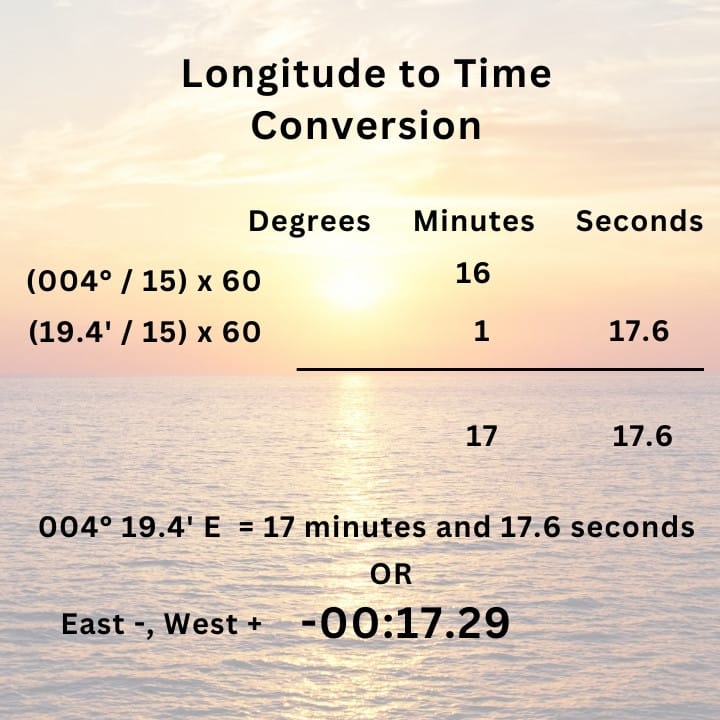
004° 19.4′ East =
(4° / 15) x 60 = 16 minutes
(19.4 / 15) × 60 = 77.6 minutes or 1 minute 17.6 seconds
004° 19.4′ East = -00:17.29
🧾 Step 4: Apply the Formula
Sunrise/Sunset = (Tabulated Time ± Longitude in Time) ± Zone DescriptionSunrise = (07:56 − 00:17.29) + 1
→ 07:38.71 + 1 = 08:39 (rounded)Sunset = (15:46 − 00:17.29) + 1
→ 15:28.71 + 1 = 16:29 (rounded)✅ Final Answer:
- Sunrise: 08:39
- Sunset: 16:29
📊 Cross-Check with Online Tools
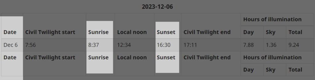
Comparing our result to tools like the NRC Sun Calculator shows close agreement.
Any minor variations are due to:
- Almanac editions
- Rounding
- Interpolation assumptions
If your computed values are within 5 to 10 minutes of trusted sources, your solution is considered accurate.
| SUNRISE | SUNSET |
| Sunrise = (Tabulated Sunrise – Longitude in time) +- Zone Description Sunrise = (07:56 – 00:17.29) + 1 Sunrise = 08:38.31 or 08:38 | Sunset = (Tabulated Sunset +- Longitude in time) +- Zone Description Sunset = (15:46 – 00:17.29) + 1 Sunset = 16:28.31 or 16:28 |
Comparing it with another online tool from the National Research Council Canada, our answers are close.
The reasons vary from interpolation to the nautical almanac we use. Rounding off is also a contributing factor.
But as long as your results don’t stray widely from other sources, The method you use to calculate sunrise and sunset should be correct.
🧠 Why Manual Sunrise/Sunset Calculation Still Matters
Even in today’s ECDIS-driven world, being able to calculate sunrise and sunset without electronics is a vital fallback navigation skill.
- Useful during equipment failure
- Enhances watchkeeping precision
- Helps determine safe daylight anchoring or departure
- Strengthens your celestial navigation foundation
💬 Many shipboard situations still call for paper-based solutions especially during audits, simulator assessments, or emergencies.
🎯 Challenge: Try It Yourself!
Using your current position and date, try calculating the sunrise and sunset using the steps above.
Then, compare your results with an online sunrise/sunset calculator. Tag your fellow seafarers and test who gets the closest result! 💪🌅
⚓ Conclusion
Calculating sunrise and sunset using the Nautical Almanac isn’t just an exam topic, it’s a practical maritime skill that boosts your confidence and capability as a deck officer.
Whether at anchor, underway, or preparing for voyage planning, this method ensures you remain ready even when the power goes out.
May the winds be in your favor.
Leave a Reply