
Gyro error is the angular difference between the reading of your gyro compass and the true geographic north.
Unlike magnetic compasses that point to magnetic north, the gyro compass aligns with true north, making it a crucial navigational tool for every seafarer.
Even though it’s highly accurate, the gyro compass can drift due to mechanical wear, electrical disturbances, or prolonged voyages.
That’s why every Officer of the Watch (OOW) must routinely check for gyro errors and log them as required by regulations and best practices.
✅ Key Takeaway: If you’re off by just 1°, you can end up 1 nautical mile off course after 60 miles of travel.
⚓ Why You Must Check the Gyro Compass Error Regularly
Checking the gyro error isn’t just a routine, it’s essential for safe, efficient, and compliant ship operations.
Here’s why:
1. 🔍 Accurate Navigation
A 1-degree gyro error may seem small, but it creates significant deviation over long distances, especially in ocean crossings.
2. 🔄 Course Correction
Knowing your gyro error lets you adjust your course and arrive precisely at your destination, avoiding costly detours.
3. 🛑 Accident Prevention
The gyro compass connects to autopilot systems, radar, ECDIS, and ARPA. An uncorrected error can mislead course plotting or create confusion during restricted navigation.
4. 📋 Compliance with Inspections
Port State Control, vetting inspectors, and classification societies often verify gyro compass errors. Non-compliance may trigger operational delays or deficiencies.
5. 💡 Efficient Passage Planning
Accurate heading = optimized fuel consumption, improved ETA, and better voyage efficiency.
🧭 What Causes Gyro Compass Error?
- Mechanical friction (from the gyroscope motor)
- Electrical interferences
- Latitude-related drift
- Aging or poorly calibrated repeaters
- Initial misalignment
Errors accumulate over time, hence the need for regular verification.

🔧 How to Check Gyro Error: 8 Methods Seafarers Trust
You don’t always need complex tools like a sextant or ECDIS overlays to check gyro error.
Some methods use celestial bodies, while others use charted objects, range lights, or simple math.
Let’s explore the most reliable ways to determine gyro error onboard.
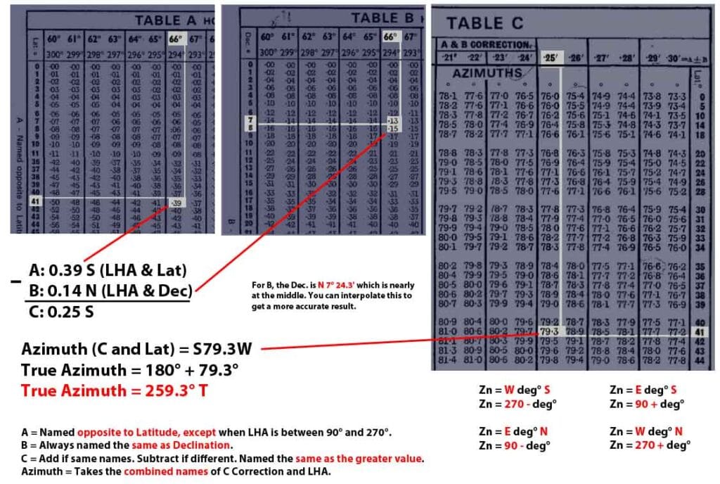
✅ Method 1: ABC Method (Using Norie’s Nautical Tables)
One of the oldest and most reliable celestial techniques, the ABC Method uses the A, B, and C azimuth tables found in Norie’s Nautical Tables.
You can use this method when you have an observed gyro bearing of a celestial body like a star or the sun.
Example: Star Betelgeuse Observation
| Parameter | Value |
| Date | 08 Apr 2014 |
| Time (UTC) | 21:07:22 |
| Place | Tarragona Anchorage |
| Position (Lat/ Long) | 41° 05.0′ N / 001° 17.3′ E |
| Gyro Bearing Observed | 259.5° |
| True Azimuth (from Norie’s) | 259.3° |
| 📍 Gyro Error | 0.2° West |
Using the date, time, and position, we can now find its Local Hour Angle or LHA using the solution below:
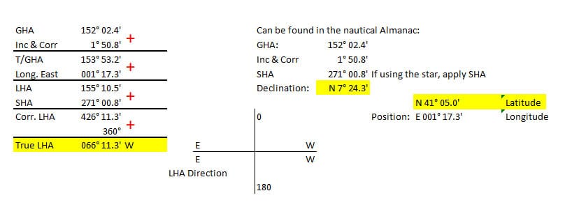
After finding the LHA, we can use it together with the latitude and declination to find the true Azimuth (or bearing of the celestial object) using the ABC Method.
Get your Nories Nautical Tables and turn to page 380 to start looking for the values based on the Latitude, Declination, and SHA.
Refer to the image below:
🧠 Formula: Gyro Error = Observed Bearing − True Bearing
Result:
Gyro Error = 259.5° − 259.3° = 0.2° West
🎥 YouTube Demo: ABC Method for Gyro Error
✅ Method 2: Sight Reduction Tables (SRT)
SRTs simplify celestial navigation without heavy math. These books tabulate the altitude and azimuth of celestial bodies based on the observer’s position and time.
Inputs used (same as in ABC method):
- Latitude: 41° 05.0′ N
- Declination: 7° 24.3′ N
- LHA: 066° 11.3′ W
Sample Tabular Calculation:
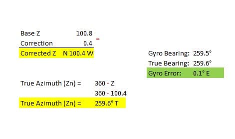
| Actual Values | Base Arguments | Base Azimuth | Tabulated Azimuth | Z Difference | Increment | Correction (inc*ZDiff/60) |
| Dec N 7° 24.3′ | 7° | 100.8 | 100.0 | -0.8 | 24.3 | -0.3 |
| Latitude N 41° 05.0′ | 41° | 100.8 | 101.0 | +0.4 | 05.0 | 0.0 |
| LHA W 066° 11.3′ | 066° | 100.8 | 100.1 | -0.7 | 11.3 | -0.1 |
| Total Correction | -0.4 | |||||
| Factor | Value |
| Z Diff | -0.7 |
| Increment | 11.3 |
| Correction | -0.1 |
| 📍 Total Correction | -0.4 |
| 🔁 Gyro Error | 0.1° East |
⚠️ Minor differences occur due to interpolation rounding or omitted decimal increments.
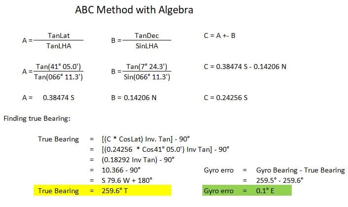
✅ Method 3: ABC Method with Algebra (No Tables)
For those who want to ditch Norie’s tables and go fully digital, this variant uses algebra and a scientific calculator.
Formulas:
- A = Tan(Lat) / Tan(LHA)
- B = Tan(Dec) / Sin(LHA)
- C = A ± B
- True Bearing = arctangent(C × CosLat) − 90°
Use the same latitude, declination, and LHA as previous examples. This method is quicker for those confident with trig functions.
Here’s what the solution looks like:
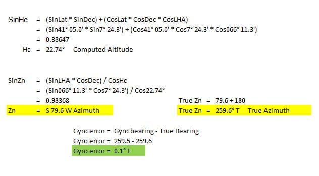
✅ Method 4: Computed Altitude Method
This technique comes from the LOP (Line of Position) approach. To find the true bearing, you must first solve for computed altitude (Hc).
Key Formulas:
- SinHc = (SinLat × SinDec) + (CosLat × CosDec × CosLHA)
- SinZn = (SinLHA × CosDec) ÷ CosHc
Using these values, you can compute the true azimuth and compare it to the gyro compass reading.
Let’s solve for the gyro error using the formula above and the values given in method 1.
✅ Method 5: Amplitude by Algebra (Sunrise or Sunset Only)
The amplitude method is a quick way to determine the true bearing of the sun at sunrise or sunset- when it appears about two-thirds of its diameter above the horizon.
At this point, refraction is minimized, and the sun is effectively at 0° altitude.
📌 Important: Only applicable during sunrise or sunset.
Formula:
SinAmplitude = SinDeclination / CosLatitude
Once you solve for the amplitude, you can determine the true bearing of the sun, then compare it with your observed gyro bearing to calculate the gyro error.
⚠️ Note: Make sure your observation time matches the moment when the sun visually touches the horizon.
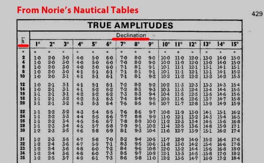
✅ Method 6: Amplitude Using Norie’s Nautical Tables
For those without calculators, Norie’s Tables also offer a way to find the sun’s amplitude using precomputed values.
Again, this method only works at sunrise or sunset, and you must interpolate between values based on your exact latitude and declination.
📖 Steps:
- Look up Sun’s Declination for the date (via Nautical Almanac).
- Use Norie’s Table for the corresponding Latitude and Declination.
- Interpolate if necessary.
- Subtract from your observed bearing to find the gyro error.
📝 Example:
If Norie’s gives a true amplitude of 89.7° and your gyro compass shows 90.2°, then:
Gyro Error = 90.2° – 89.7° = 0.5° East
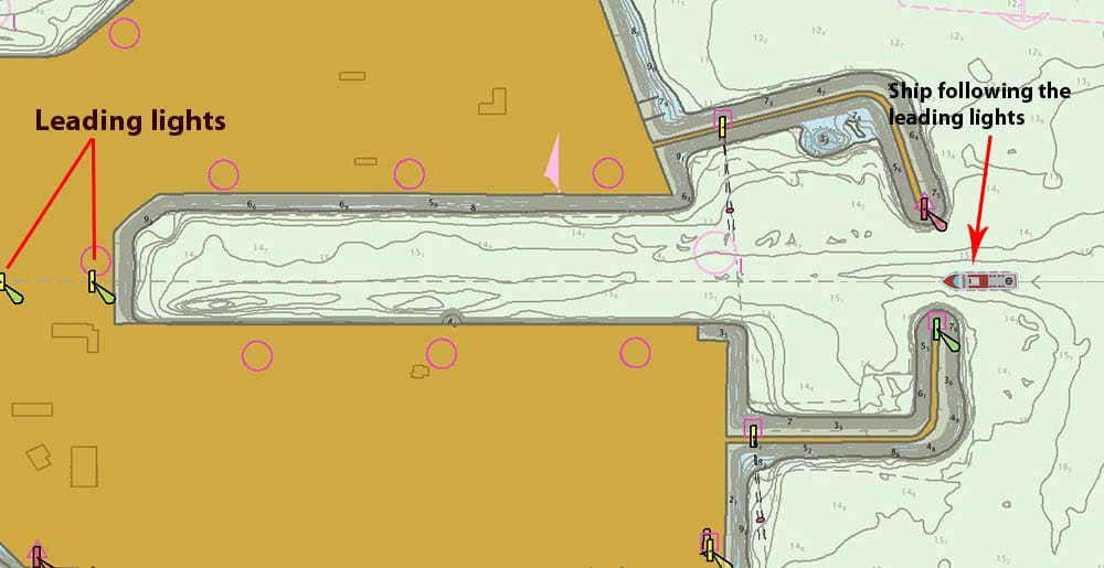
✅ Method 7: Leading Lights (Range Lights)
One of the quickest and most practical methods, especially during port approaches or pilotage.
Leading lights consist of two lights (front and rear) aligned on a fixed bearing. When a vessel is exactly on the safe channel, these lights appear vertically aligned.
📌 Procedure:
- Take a bearing of the lights using your gyro compass.
- Compare with the charted bearing (usually marked on the chart or pilot book).
- The difference = gyro error.
🧭 Example:
If the leading lights should bear 270.0° and your gyro reads 270.3°, then:
Gyro Error = 0.3° West✅ This method is ideal during harbor transits, berthing, or pilotage operations.
✅ Method 8: While Berthed or Inside a Lock
Sometimes, even a static berth or lock wall can be used to determine gyro error — if you know its exact charted direction.
📍 Example:
A pilot informed us that the lock wall was aligned at 092.5°, but our gyro compass showed 092.8°.
Gyro Error = 0.3° West
However, this method has limitations:
- Mooring line tension can slightly rotate the ship.
- Deformed fenders or berth shape may distort actual heading.
- Not all berths have clearly charted orientations.
✅ Use this method with caution and only when other options are unavailable.
📝 Summary of 8 Methods to Check Gyro Compass Error 📌
| Name | Tools Needed | Best Use Case |
| 1️⃣ ABC Method (Norie’s Tables) | Norie’s Nautical Tables | Open sea with visible celestial body |
| 2️⃣ Sight Reduction Tables | SRT volumes + calculator | Celestial nav without needing deep math |
| 3️⃣ ABC Method with Algebra | Scientific calculator | Fast math-based solution without tables |
| 4️⃣ Computed Altitude Method | Calculator + formulas | LOP-based celestial fixes |
| 5️⃣ Amplitude by Algebra | Calculator + sunrise/sunset | Observing sun near horizon (no tables required) |
| 6️⃣ Amplitude with Norie’s Tables | Norie’s Tables | Using tables for sunrise/ sunset observations |
| 7️⃣ Leading Lights | Chart + gyro compass | Port approaches, range lights available |
| 8️⃣ While Berthed or Inside Locks | Chart + heading check | Emergency checks in static or locked position |
🔍 Pro Tip 1: Choose your method based on location, visibility, and available tools. For redundancy, cross-verify using 2 different methods during long voyages.
💡 Pro Tip 2: Always log your gyro error in the deck logbook and monitor for trends. An increasing error may signal mechanical failure or need for recalibration.
❓ FAQ: Gyro Compass Error & Calibration
🔧 What is gyro error in navigation?
It is the angular difference between the reading of the gyro compass and the true north. A positive error indicates a reading east of true north, and a negative error indicates west.
🕒 How often should you check gyro error onboard?
Ideally, once every 4-hour watch, especially during open sea navigation and port approaches.
📚 Do you need a sextant to check gyro error?
Not always. Some methods use celestial bodies without sextants, relying on sight reduction tables, calculators, or charted landmarks.
⚠️ Can gyro error change during a voyage?
Yes. Changes in latitude, temperature, vibration, and even electrical interference can cause gyro drift.
🧭 What’s the difference between compass error and gyro error?
- Compass error: Difference between compass north and true north (magnetic).
- Gyro error: Difference between gyro compass heading and true north (geographic).
📣 Share Your Favorite Method!
Have you used any of these gyro error techniques?
Got a shortcut or trick of your own?
- 💬 Share it in the comments and help other navigators stay on course.
- 📹 Check out our YouTube Channel for a full walkthrough of the ABC method and more.
May the winds be in your favor.
Featured image: Chief Officer Domingo Antonio Cargiulo. You can follow him on Instagram.
Leave a Reply